The management of underground utilities, which is a complex maze of pipes, cables and conduits, has always been a major impediment to construction and infrastructure projects. This typically also leads to expensive delays due to wrong or incomplete records, and dangerous hits on utility lines among others. Scan-to-BIM technology has revolutionized the mapping of this secret world through digital means that are highly accurate. Involving state-of-the-art scanning methods in BIM technological platforms, this method enables the creation of sophisticated three-dimensional (3D)models for subsurface networks. This article discusses the latest innovations in Scan to BIM including technologies, software and real-life applications for changing our understanding and interaction with under landscapes.
Key Technologies in Modern Scan to BIM
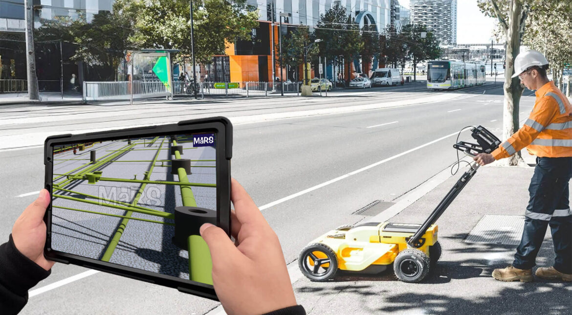
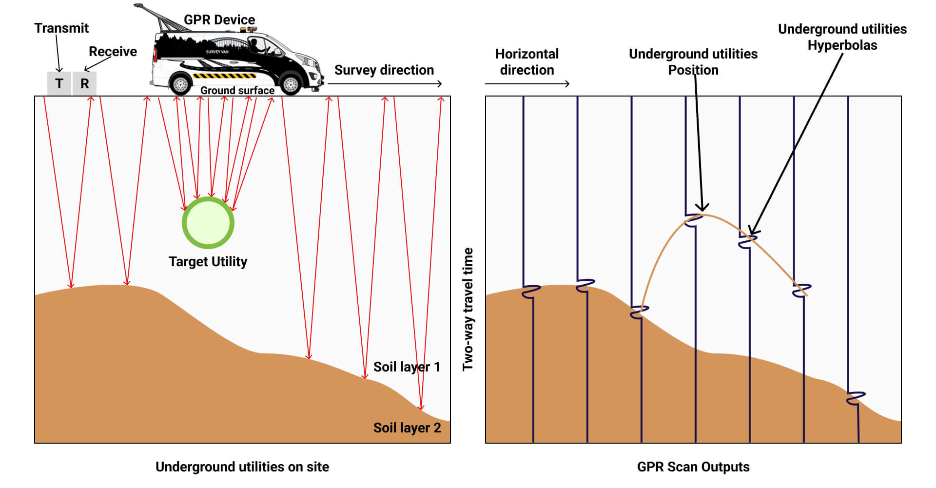
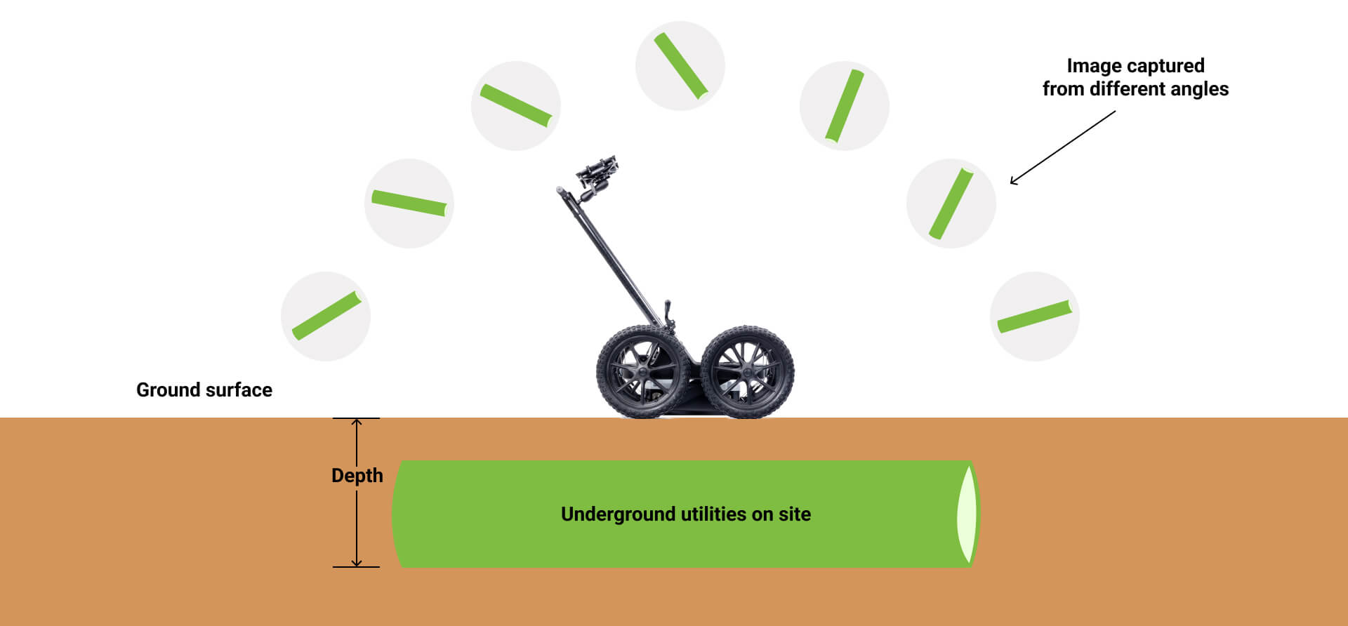
To create a 3D model of the buried assets with laser scanning (LiDAR) that is accurate, point cloud to BIM services uses point cloud data. The operation emits electromagnetic waves into the ground that reflect from subsurface objects on the surface known as Ground Penetrating Radar (GPR). For example, GPR can find underground utilities such as plastic pipes even though they are made from different materials.
On the other hand, photogrammetry in BIM is employed by Scan-to-BIM in taking overlapping photographs of excavations and exposed utility lines, an old aerial surveying technique. 3D Data fusion for BIM algorithms integrate these sources of information into a single unified model that presents an all-encompassing view of underground infrastructure. Due to this, designers, engineers and construction teams have access to precise and dependable information for decision-making purposes.
Advancements in Software and Algorithms
The conversion of raw data into 3D BIM models involves the use of cutting-edge software and algorithms. Point cloud to BIM processing software is necessary for removing noise, outliers and unwanted objects from the vast amount of data that is collected during scanning. The aboveground part of a tree system consists of machine learning-based automated feature extraction algorithms that can pick out underground assets from among the point cloud data.
There needs to be the creation of such a model as a 3D (three-dimensional) representation which reveals the existing infrastructure on the ground. For example, utilities are included in this model showing their material, diameter and depth characteristics. Once generated, the BIM model can be integrated with other project designs hence improving coordination amongst various disciplines and stakeholders.
Incorporation of AI and ML into Scan-to-BIM software has been an area witnessing an acceleration in development leading to more automation as well as accuracy during data handling or modeling workflow.
Key Technologies and Advancements in Scan to BIM for Underground Utility Mapping
| Technology | Description | Benefits | Challenges |
| Laser Scanning (LiDAR) | Emits laser pulses to capture precise 3D point cloud data of underground structures. | High accuracy, detailed 3D models, works in various conditions | Costly equipment, potential for signal interference. |
| Ground Penetrating Radar (GPR) | Emits electromagnetic waves to detect the presence and depth of underground utilities | Detects non- metallic utilities, works in various soil conditions | Lower resolution than LiDAR, requires skilled interpretation |
| Photogrammetry | Captures overlapping photographs to create 3D models and visual context | Provides visual context, complements LIDAR and GPR data. | Limited to surface features, requires specialized software |
| Data Fusion | Combines data from LiDAR, GPR, and photogrammetry into a unified model. | Comprehensive view of underground infrastructure, improves decision- making | Requires sophisticated algorithms, potential for data inconsistencies |
| Point Cloud Processing | Software tools to clean, filter, and segment point cloud data into meaningful objects | Reduces noise and outliers, improves data quality. | Requires specialized software, can be time-consuming |
Real-World Applications and Case Studies
When it comes to utility infrastructure projects risks, scan to BIM modeling Services plays a key role in the mapping of existing utilities before any massive construction commences. It is this exhaustive understanding of the subsurface landscape that helps avert expensive utility strikes, ensures conformity to safety rules and minimizes disturbances to current services.
Point cloud to BIM is also having a big impact in the area of asset management. BIM models derived from scans are being used by utility companies to create digital twins for their networks. These virtual copies help provide important insight into underground assets’ state, location and performance thus facilitating preventative maintenance procedures, optimization of resources and decisions based on data.
Also, the construction and excavation industry has adopted Scan to BIM services as a way of reducing risks and enhancing safety. By mapping out underground utility services with high precision before starting any construction project, contractors can avoid costly delays and potential dangers. This means that employees are much safer in their working environments while projects rarely overstay due to unforeseen clashes with utilities.
Related blog: The Role of Scan to BIM in Building Maintenance
Several real-life examples of how Scan-to-BIM works have been discussed in numerous studies. For instance, it was used during major urban redevelopment for developing an accurate model of already existing infrastructure below the ground level. Conflicts that may arise from the new development were anticipated by using this technique hence making it possible for engineers to come up with designs that could mitigate the rate of redoing work and ensure timely completion of projects at lower costs.
In another case study, an electricity company employed 3D scanning to BIM technology in order to create a virtual representation of its entire underground networks comprising pipes and cables. With this digital twin, service providers were able not only to improve their maintenance schedules but also to decide which repair should be done first while lengthening the useful life of each asset they own. The examples above are just among some demonstrations showing how scanning techniques revolutionize our ways of managing utilities beneath the ground.
Conclusion
The paradigm shift presented by the innovations in Scan-to-BIM technology concerning our perception and management of the complex underground world is a game changer. These breakthroughs permit precise, data-rich models of subsurface infrastructure through such means as laser scanning, ground penetrating radar and sophisticated software with artificial intelligence algorithms. This approach has transformed safety conditions, increased efficiency levels and cut down expenses throughout the industry from construction to utility asset management.