Scan to BIM Services in Texas
We specialize in delivering precise and efficient Scan to BIM services across Texas. Our expertise lies in converting point cloud data into detailed 3D BIM models, facilitating seamless project execution for architects, engineers, contractors, and building owners.
Our Scan to BIM Expertise for Texas Construction Projects
MaRS BIM Solutions has showcased its expertise in scan-to-BIM services for several construction projects in Texas. We have used our skills as per the Texas Building Codes and Standards to bring out the best in each conversion project. Our experienced professionals have made sure to deliver accurate BIM services to each client. Our excellence comes from continuous improvement and upgrades; all this has made us a trustworthy scan to BIM conversion service provider in Texas.
Our Scan to BIM resources in Texas
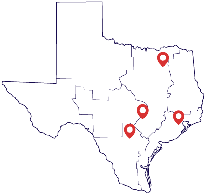
We have been providing scan to BIM services in Texas for many years now. To ensure that our clients get the absolute best, we have the best industry resources in Dallas, Austin, Houston, and San Antonio. Along with our competent and skilled human resources, i.e., our employees, we also have the latest BIM software and other technologies that enable us to focus on quality. We take additional supervision to ensure that all our systems are in proper working conditions so there is no difference or delay in the conversion processes.
We cover multidisciplinary BIM Solutions in Texas
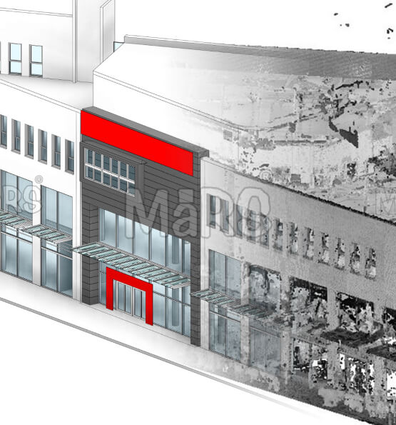
Architectural Scan to BIM
We extract architectural elements from point cloud data and build accurate 3D Revit models. These elements include walls, slabs, ceilings, roofs, windows, doors, and staircases. The models are used for renovation planning, documentation, and design validation. We follow industry standards like AIA and deliver outputs in LOD 100 to LOD 500.
Structural Scan to BIM
We convert scan data into structural BIM models, including all primary and secondary load-bearing elements. We model columns, beams, foundations, trusses, slabs, joists, and bracings. These models are used for structural evaluation, retrofit designs, and steel detailing. Accuracy is maintained within ±5mm, ensuring reliable structural documentation.
MEP Scan to BIM
We extract MEP components from scan data to create detailed models. We model ductwork, pipes, cable trays, fire protection lines, HVAC systems, and other building services. This is especially useful for renovation, retrofitting, or coordination with new systems. Our models support clash detection and integration with Revit MEP and Navisworks.
What You Get with Our Scan to BIM Services
1. Precise 3D Models from Laser Scans
We convert point cloud data into Revit models that match the exact site conditions.
2. Point Cloud Processing
We handle formats like E57, RCP, LAS, and XYZ. Our team cleans, aligns, and registers scan data.
3. LOD-Based BIM Outputs
We deliver models in LOD 100, 200, 300, 400, or 500 based on your project requirement.
4. Scan to Revit Modeling
We trace building geometry such as walls, floors, beams, slabs, and ceilings directly from scan data.
5. Structural and MEP Element Modeling
We model pipes, ducts, conduits, cable trays, structural columns, and framing based on point cloud scans.
6. 2D Drawings from Scan-Based Models
Floor plans, sections, and elevations are generated directly from the Revit model for documentation.
7. Model Accuracy Validation
We verify model accuracy by comparing it to the original scan. Tolerances are typically within ±5mm.
8. Output Formats for BIM Use
Final deliverables include RVT, IFC, DWG, and NWC formats suitable for BIM coordination.
Our Scan to BIM Modeling Workflow in Texas
- We begin by understanding the project scope.
- Our team reviews building size, complexity, and access conditions.
- We define the Level of Detail (LOD) required — such as LOD 200, 300, or 400.
- We choose the right scanning equipment based on environment and accuracy goals.
- A scanning plan is created, including the scan positions and coverage strategy.
- After scanning, we process all raw scan files.
- Using tools like Leica Cyclone, FARO Scene, or ReCap Pro, we register the scans.
- Registration means combining multiple scan stations into one single, accurate model.
- We use reference targets, spheres, or natural features for alignment.
- The registered point cloud is checked for alignment errors and noise.
- We clean the point cloud by removing duplicate points, background noise, and irrelevant data.
- Non-essential elements like people, vehicles, or clutter are trimmed out.
- We crop the dataset to the required modeling boundary.
- The cleaned and optimized point cloud is then exported in formats like E57, RCP, or LAS.
- The cleaned point cloud is imported into Autodesk Revit.
- Our BIM experts model architectural, structural, and MEP elements directly from the scan.
- This includes walls, slabs, roofs, columns, beams, pipes, ducts, and equipment.
- We follow BIM standards (like AIA or UK BIM Level 2) and match required LOD.
- Typical accuracy is maintained within ±5mm from the real-world dimensions.
- We conduct a full QC review of the BIM model.
- Our team compares the model against the original point cloud to check alignment.
- We check dimensions, element placement, geometry accuracy, and completeness.
- Visual inspections, clash tests, and deviation analysis are performed.
- Corrections are made before final approval.
We deliver all project files in your requested formats:
- BIM Models: RVT, IFC, NWC
- 2D Drawings: DWG, PDF
- Point Cloud: RCP, E57, LAS
- Reports: Excel schedules, PDF summaries, QC reports
Files are organized and shared securely through cloud storage or file transfer platforms. We also provide model usage instructions if needed for your internal team.
Software Proficiency


Customized BIM Softwares
Customized Revit Plugins
& Many More
Why choose MaRS over other Scan to BIM Services provider in Texas?
Texas Building Code Expertise
We understand local codes, building materials, construction methods, and climate-related considerations unique to Texas. Whether you're in Houston, Austin, Dallas, or San Antonio, we bring location-specific insights to every project.
High-Accuracy Output
Our models maintain up to ±5mm precision, verified through multiple QA checks, cross-referenced against point cloud data for reliability during renovation, retrofit, and facility planning.
Custom LOD & Formats
We deliver models at LOD 100 to LOD 500, as per your project stage—whether conceptual design, construction, or asset management. Outputs are compatible with Revit (.RVT), Navisworks (.NWC/.NWD), IFC, DWG, and other formats you use.
Quick Turnaround
With a dedicated in-house team and streamlined workflows, we consistently meet tight deadlines without compromising on quality—even on large-scale or multi-building projects.
End-to-End Support
From initial scanning and registration to Revit modeling, coordination, and QA delivery, we offer a one-stop solution so you don’t have to manage multiple vendors.
20 +
Years Experience
850 +
happy customer
1800 +
Projects Completed
265 +
Qualified Employees
Scan to BIM FAQs
We accept point clouds in formats such as E57, RCP, RCS, LAS, and XYZ. These are compatible with modeling software like Revit and AutoCAD.
We deliver BIM models in .RVT (Revit), .IFC, and .NWC/.NWD (Navisworks). We also provide 2D drawings in .DWG, .PDF, or .DXF formats.
Yes. We can model only architectural, structural, or MEP systems based on your scope. You can also specify which areas to include.
Yes. We specialize in creating BIM models from scan data of old or irregular structures. These include historical, commercial, and residential buildings.
Yes. Scan to BIM is ideal for renovation, retrofit, and refurbishment projects.
We create accurate as-built models that help contractors plan structural changes and new installations.
Yes. If your point cloud is geo-referenced, we maintain the original coordinate system in the BIM model.
We also align models to project north or true north, based on your needs.
Yes. From one scan, we can create separate models for Architecture, Structure, and MEP.
We also offer combined federated models for coordination.
Yes. We generate 2D floor plans, elevations, and sections directly from the Revit model.
These are delivered in DWG, PDF, or DXF formats.
Yes. We can link or merge our models with existing BIM files, project templates, or consultant models for coordination.
Get In Touch
Feel free to reach out to us for any inquiries or to discuss your project needs.