Making the right decision regarding the collection and modeling of building data is crucial when starting a construction or renovation project. Two primary approaches dominate this landscape: Scan to BIM and traditional methods. Scan to BIM creates highly precise and comprehensive digital models of existing structures by utilizing modern 3D laser scanning technology along with Building Information Modeling. In contrast, traditional methods involve manual measurements and basic CAD drawings. Each approach has advantages and disadvantages, and knowing these differences will help you choose the strategy that will work best for your project. This comparison explores the benefits and limitations of both traditional methods and Scan to BIM, helping you choose the best option for your requirements.
What is Scan to BIM?
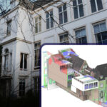
Scan to BIM is an advanced approach that utilizes Building Information Modeling (BIM) with 3D laser scanning technology to produce precise and complete digital representations of real buildings. This process involves capturing accurate spatial data from an existing site or building using laser scanners, which then generate point clouds—dense collections of 3D data points that represent the scanned environment.
Services Included in Scan to BIM
A variety of activities are included in scan to BIM services, which are intended to collect, handle, and model data from pre-existing structures into complete Building Information Models (BIM). The following is an overview of the main services that are usually part of a Scan to BIM workflow:
Site Survey and Preparation
A complete site survey is carried out to determine the needs and scope of the project in advance of starting the scanning process. Evaluating entry locations, spotting possible barriers, and organizing the scanning approach are all included in this. Scanning efficiency and protection of all relevant regions are guaranteed by site preparation.
3D Laser Scanning
The fundamental technology of Scan to BIM services is 3D laser scanning. Using laser scanners, millions of data points are extracted from the structure. A digitized picture of the building’s surface called a point cloud is produced by these scanners. The external as well as internal measurements of the construction are quite accurate due to this technique.
Point Cloud Data Processing
Once the scanning is complete, the raw point cloud data is processed to correct errors and clarify the model. This step includes aligning and combining multiple scans, filtering out noise, and ensuring data accuracy. The cleaned point cloud is then prepared for integration into BIM software.
BIM Modeling
In this phase, the processed point cloud data is imported into BIM software to create a detailed 3D model of the building. The BIM model includes geometric, spatial, and contextual information about the structure, including architectural, structural, and MEP (Mechanical, Electrical, and Plumbing) components.
Model Verification and Quality Assurance
Quality assurance is crucial to ensuring that the BIM model accurately reflects the as-built conditions. This involves reviewing the model for accuracy, consistency, and completeness. During this stage, any differences between the point cloud data and the BIM model are corrected.
Documentation and Deliverables
Once the BIM model is complete, detailed documentation is provided, including 3D models, floor plans, elevations, and sections. These deliverables are important for project planning, design, and facility management.
Coordination and Integration
Scan to BIM services often include coordinating with other project teams, such as architects, engineers, and contractors. The BIM model is combined with different design and construction data to ensure compatibility and facilitate smooth project workflows.
Client Review and Feedback
Before finalizing the model, clients are allowed to review and provide feedback. This ensures that the BIM model meets their requirements and expectations.
Final Delivery and Handover
The final BIM model and associated documentation are delivered to the client. This includes providing the model in the required formats and ensuring that all deliverables are complete and accurate.
Post-Project Support
Some Scan to BIM services offer post-project support, including assistance with model updates, additional data integration, and troubleshooting. This ongoing support helps clients maintain and utilize the BIM model effectively throughout the building’s lifecycle.
By containing these complete services, Scan to BIM ensures that clients receive accurate, detailed, and actionable data for effective project planning, design, and management.
What are Traditional Services?
Traditional surveying and modeling services contain the conventional methods used to measure, document, and represent physical spaces and structures. These techniques were widely used before the advent of advanced digital technologies and involve a range of manual and less precise methods.
Services Included in Traditional Surveying and Modeling
For many years, the construction and real estate industries depended heavily on traditional surveying and modeling techniques. Compared to modern Scan to BIM services, these services combine manual and less modern technological methods. Here’s a detailed look at what traditional services typically include:
Site Surveying
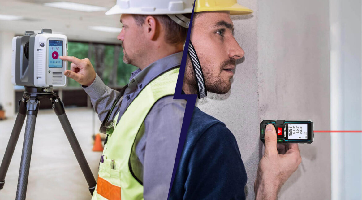
Site surveying is a crucial aspect of traditional methods, focused on measuring and documenting the physical characteristics of a site. Using manual tools like theodolites and total stations, this process involves determining property boundaries, topographical features, and landlines. To produce exact site plans and boundary maps, surveyors take measurements of angles and lengths. Surveyors take measurements of the sections, elevations, and floor plans of existing buildings. Usually, tape measures, laser distance meters, and other hand tools are used to take these measurements, which are then either recorded on paper or in basic digital formats.
Manual Drafting
Manual drafting involves creating physical representations of architectural and engineering designs. Traditionally, drafting tables, pencils, and rulers have been used by architects and engineers to manually create detailed drawings. Floor plans, sections, elevations, and construction details are all included in these drawings. These hand-drawn plans are subsequently copied onto designs or other material objects and given to construction teams and other relevant parties. Using chemical processes, large sheets of paper are printed with physical copies of the drawings during the designing process.
Photogrammetry
Photogrammetry involves using photographs to create measurements and models. Taken from aircraft or drones, these images capture large-scale site information from above. While less precise than modern methods, aerial photographs help in mapping land features and planning large projects. These are ground-level images captured to document building facades or interior spaces. Photogrammetry software analyzes these images to extract measurements and create basic models.
Topographical Mapping
Topographical mapping involves documenting the terrain and land features. Using conventional surveying methods to create maps that display land contours and elevation changes. These maps are useful for planning construction projects and for understanding the topography. Documenting both natural features (e.g., hills, rivers) and man-made features (e.g., roads, buildings) on the land. These details are critical for site analysis and planning.
Building Inspection
Building inspection involves evaluating the physical condition of structures. Building conditions are assessed by inspectors to spot problems like deterioration, structural flaws, or safety risks. Visual inspections and manual testing are frequently used in this. Checking that construction methods, materials, and general compliance with building codes are all in line with regulatory and safety requirements.
Manual Data Collection
Manual data collection involves gathering information directly from the site. Collecting data using traditional tools like tape measures, clinometers, and leveling instruments. Measurements are recorded manually on paper or in basic digital formats. Documenting collected data in physical logbooks or forms can be time-consuming and prone to errors compared to digital data management systems.
Design Documentation
Design documentation includes creating and maintaining records of architectural and engineering designs. Detailed drawings of building designs, including layout, materials, and finishes. These are produced by hand or using CAD software and used throughout the construction process. Structural, electrical, and mechanical plans developed by engineers. These plans detail the technical specifications and systems within the building.
Coordination and Communication
Coordination and communication involve managing project details among stakeholders. Discuss project details and progress in person with team members, clients, and other stakeholders. This often involves sharing printed documents and physical drawings. Using printed plans and documents to coordinate between different teams and ensure that everyone is working from the same information.
Project Management
Project management involves overseeing the construction process and ensuring project goals are met. Creating and managing project timelines using manual methods, such as Gantt charts or spreadsheets, to track progress and deadlines. Managing project budgets and costs using spreadsheets or paper records. This includes tracking expenses, managing resources, and ensuring that the project stays within budget.
Traditional modeling and surveying services primarily rely on paper records and manual procedures. Even though these techniques have been essential to the planning and administration of building projects, they are frequently less accurate and efficient than more recent digital methods like Scan to BIM. However, they offer a vital basis for understanding and managing real estate and building plans.
Which is Best for Your Project?
According to the requirements of your project, you can choose between traditional methods and Scan to BIM. Scan to BIM excels at accuracy and detail, which makes it perfect for projects requiring accurate information, facility management, and complicated renovations. Creating an accurate digital model from 3D scans increases productivity and lowers mistakes.
However, for less complex projects where extreme precision is not required, conventional techniques might be more economical. They require manual drafting and measurement, which can be difficult and unclear. Assess the complexity of your project, the level of precision that is necessary, and your available funds to decide on the best course of action.
Read our Latest Blog: How Scan to BIM is Revolutionizing the Real Estate Market
Conclusion
When deciding between Scan to BIM and traditional methods for your project, consider the specific needs, budget, and goals of your project. Scan to BIM offers unparalleled accuracy, efficiency, and a comprehensive digital model that integrates seamlessly with modern construction and facility management processes. It’s ideal for complex projects requiring detailed data and long-term maintenance planning.
On the other hand, traditional methods may be more suitable for smaller, less complex projects where high precision and advanced modeling are not as critical. However, the manual nature of traditional methods can introduce errors and inefficiencies that may impact the overall success of the project.
Ultimately, if your project demands precision, real-time collaboration, and detailed insights, Scan to BIM is the superior choice. For less demanding scenarios, traditional methods can still provide adequate results. Assess your project’s requirements carefully to determine the best approach for achieving your goals.